Beyond 3D models: why utilities need Gaussian splatting
As cities become denser and infrastructure grows ever more complex, accurately mapping underground utilities is emerging as a critical engineering challenge. According to the American Society of Civil Engineers (ASCE), aging underground pipelines and cables contribute to high maintenance costs and frequent service disruptions in many urban centers.
Meanwhile, aerial data collection—once heralded as the breakthrough for surveying—can be hampered by restricted airspace, towering buildings, and the sheer volume of above-ground obstacles. The result? Gaps in data, incomplete visualizations, and lingering uncertainty about the exact state and location of buried infrastructure.
Mapping underground utilities in urban environments
Beyond the technical challenges of data collection, the lack of precise geolocation for underground utilities poses serious safety risks. Utility networks function as an invisible map beneath cities, but without accurate documentation, their locations remain uncertain. When maintenance or new installations are required, utility owners and contractors face significant hazards. Accidentally striking an unmarked cable or pipeline can lead to severe consequences, including major service disruptions, accidents, and even fatalities.
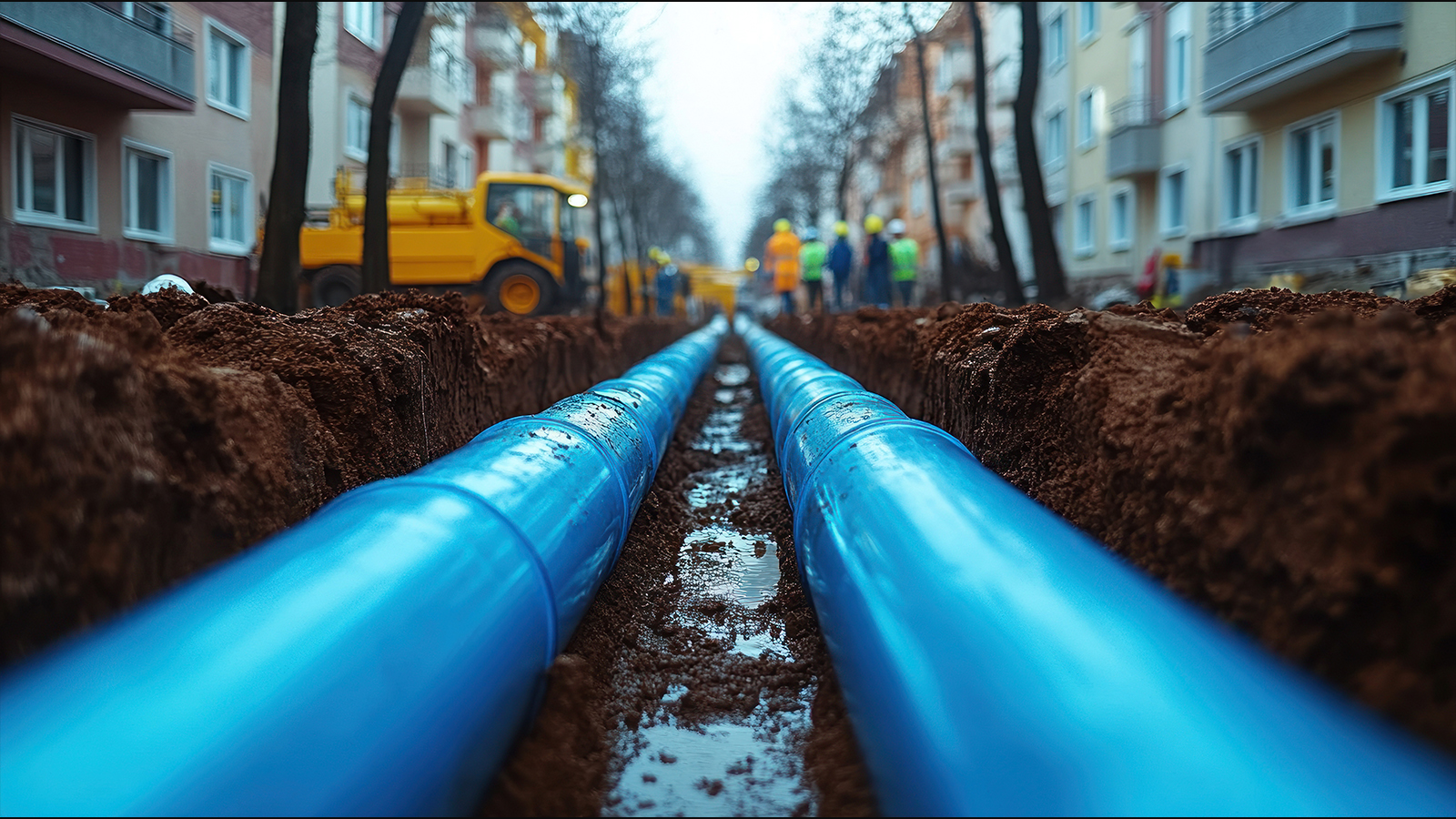
Historically, traditional surveying methods have been used to measure underground utilities. This process typically involves hiring a land surveyor on demand to measure pipe locations while trenches are open. However, this approach presents multiple challenges. The necessity of scheduling surveyors at precisely the right time can delay projects, and the method itself is inherently limited.
“Gaussian splatting at Pix4D is not just visually rich but also georeferenced, meaning that the reconstructed model accurately aligns with real-world coordinates. For utility professionals requiring precise positional accuracy, Gaussian splatting is fully compatible with RTK (Real-Time Kinematic) positioning systems, further enhancing the reliability of trench documentation."
Most surveyors rely on GNSS rovers, which require the use of offsets since they cannot enter trenches due to safety regulations. This results in approximations rather than exact measurements. Additionally, surveyors must work quickly before trenches are closed, increasing the risk of missing critical data points. GNSS rovers can only capture individual points and lines, which do not fully represent the true complexity of buried infrastructure.
Ground-level data capture for underground utilities
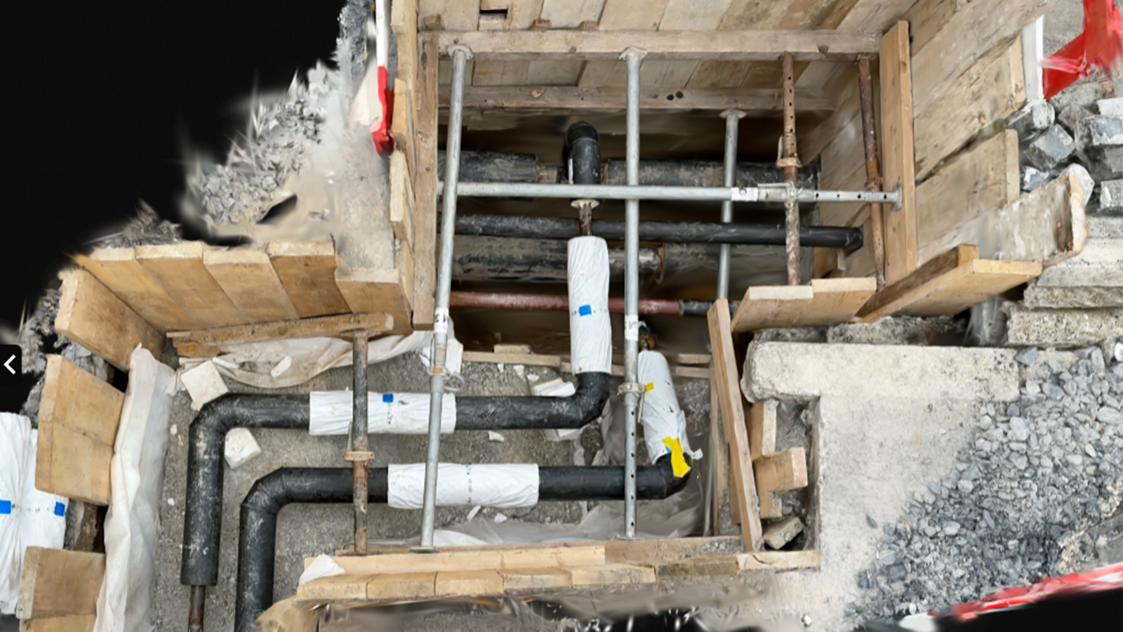
It’s in this challenging urban context that traditional photogrammetry often meets its limits. Deep trenches, narrow corridors, and crowded streetscapes complicate image capture, yielding inconsistent or suboptimal 3D outputs. These realities underscore the need for a new era of modeling—one that transcends the inherent constraints of conventional photogrammetry. Enter Gaussian splatting, a cutting-edge technique offering hyper-detailed, photorealistic reconstructions from ground-level data.
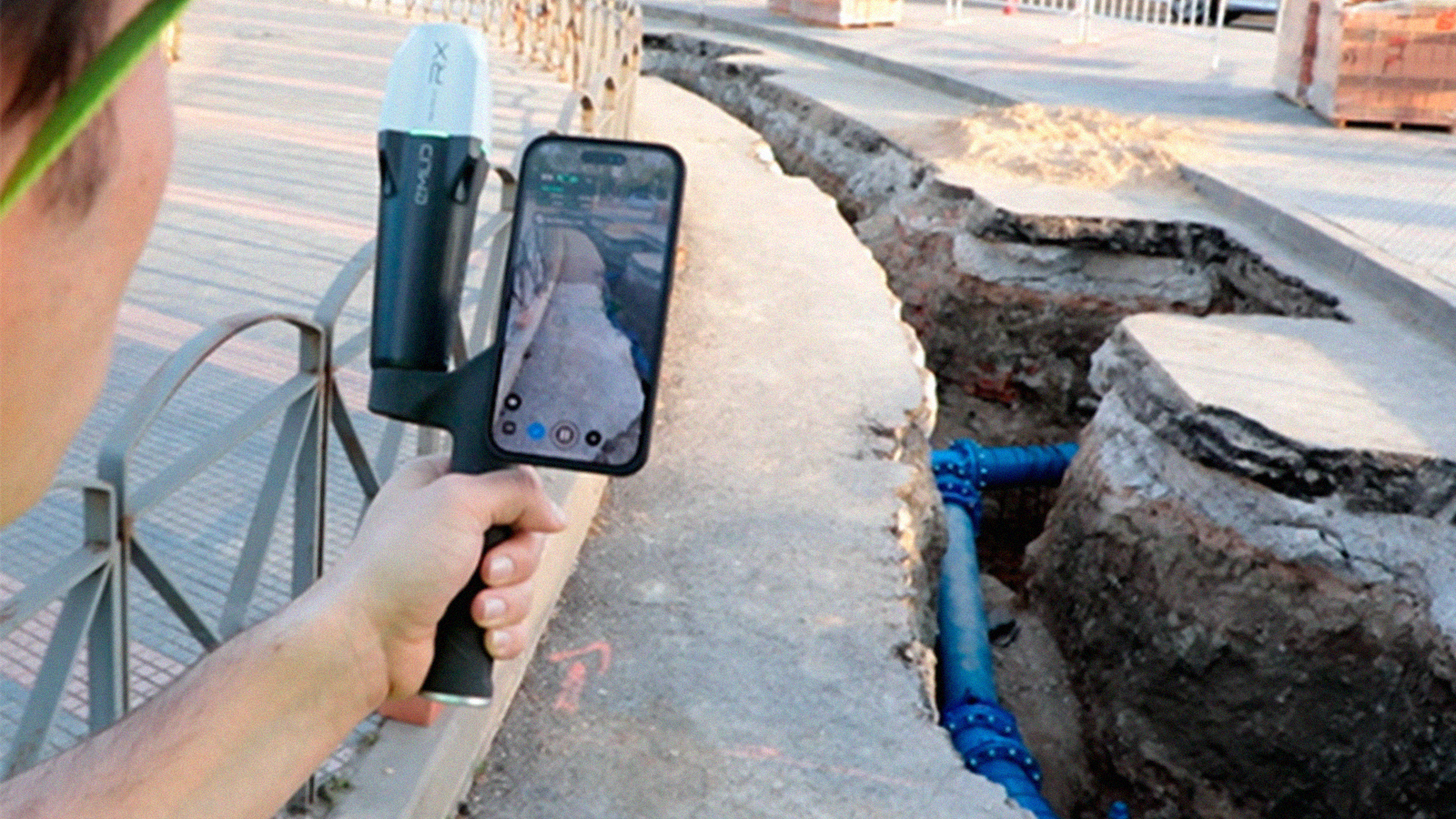
In what follows, we’ll explore how this innovation can transform trench mapping and underground utility projects in dense urban environments, bringing new levels of clarity and confidence to engineers on the front lines. Professional smartphone scanning tools like PIX4Dcatch offer a practical and reliable solution, allowing teams to capture ground-level data with ease while bypassing drone regulations.
When paired with Gaussian splatting—a feature that transforms raw scans into hyper-detailed, photorealistic 3D models—the result is improved trench mapping and underground utility documentation providing utility engineers with highly detailed trench visualizations.
Terrestrial capture for utilities: bringing Gaussian splatting to your smartphone
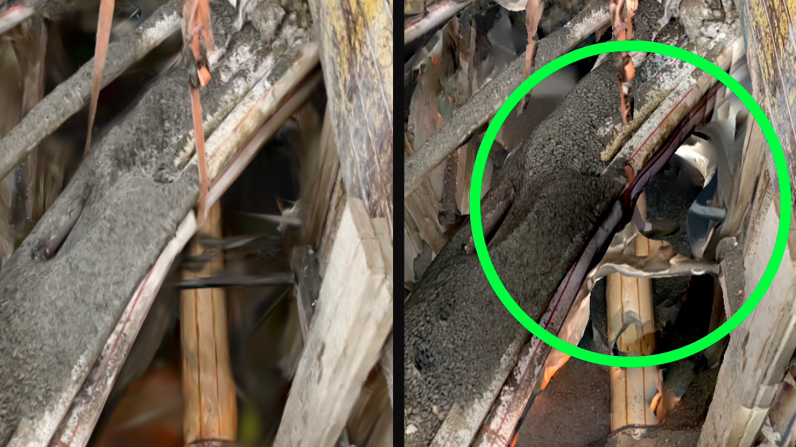
Unlike traditional photogrammetry, which can struggle to fully reconstruct complex environments from captured images, Gaussian splatting enables a more comprehensive representation of the scene, ensuring that pipes, conduits, soil conditions, and surrounding structures are recorded with clarity.
This results in fewer disputes, as the highly detailed reconstruction provides clear and indisputable visual evidence of the trench at the moment of excavation. Engineers and field crews can now capture hyper-detailed imagery from a smartphone or tablet, knowing that Gaussian splatting will transform those images into a complete 3D model, free from the gaps and inconsistencies that can be found in traditional 3D textured meshes or point clouds.
Gaussian splatting at Pix4D is compatible with RTK devices
Additionally, at Pix4D, Gaussian splatting is not just visually rich but also georeferenced, meaning that the reconstructed model accurately aligns with real-world coordinates. For utility professionals requiring precise positional accuracy, Gaussian splatting is fully compatible with RTK (Real-Time Kinematic) positioning systems, further enhancing the reliability of trench documentation.
When combined with RTK-enabled mobile devices or ground control points (GCPs), Gaussian splatting benefits from survey-grade accuracy, ensuring that every utility placement is recorded with centimeter-level precision. This is especially valuable in dense urban areas, where multiple utilities intersect, and even minor positional errors can lead to costly mistakes or service disruptions.
By integrating RTK data, field teams can ensure the highest level of accuracy in their digital reconstructions, making it easier to cross-reference trench models with GIS databases, CAD drawings, and existing utility maps.
This compatibility means that Gaussian splatting is not just a visualization tool—it is an engineering-grade solution. Whether capturing a new utility installation, documenting trench conditions before backfilling, or assessing damage, the ability to pair Gaussian splatting with RTK positioning ensures that every model is both hyper-detailed and geographically precise, providing a trusted digital record for future excavation and asset management.
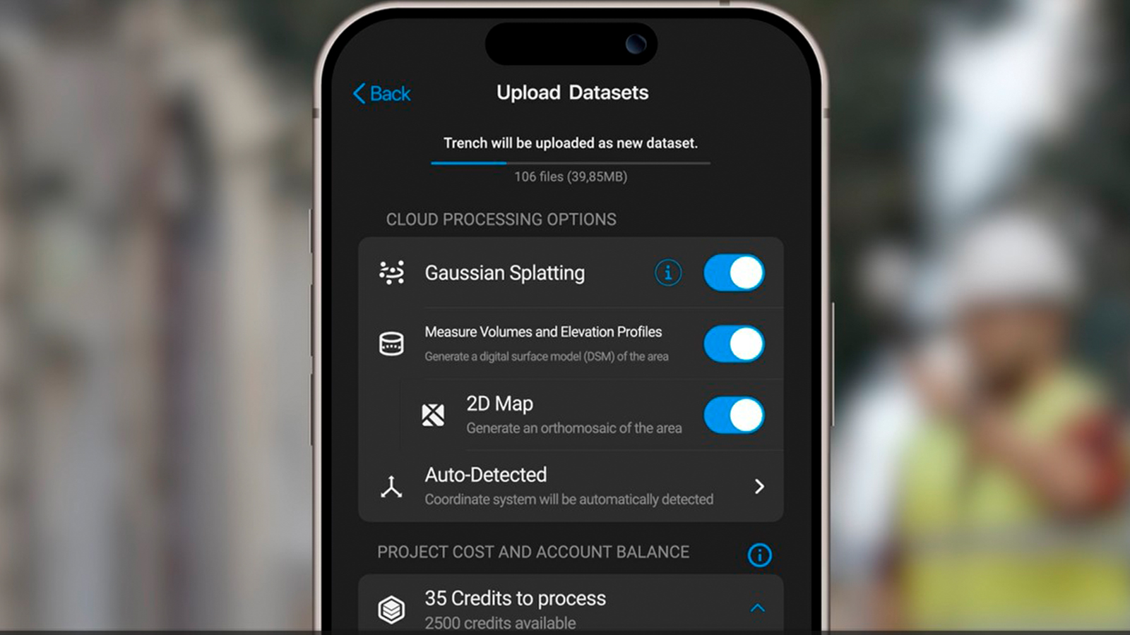
Processing in the cloud: bringing Gaussian splatting to life
Once field data is captured, the next step is processing the images into a fully realized Gaussian splatting model. This is where PIX4Dcloud plays a key role, providing a seamless and efficient cloud-based workflow that eliminates the need for high-performance local hardware. Processing Gaussian splatting models in the cloud ensures that utility professionals can quickly transform captured images into a detailed, photorealistic 3D reconstruction, ready for visualization and analysis.
You can also try our demo dataset here
For utility applications, cloud processing offers several key advantages. First, it removes hardware limitations, allowing large datasets—such as those collected along long trench lines—to be processed without overloading local devices. Instead of waiting for hours or managing heavy files manually, engineers can simply upload their images to PIX4Dcloud and let the platform handle the computational workload. The cloud-based approach also ensures that data is always accessible, making it easy for field teams, office-based engineers, and stakeholders to view, analyze, and share results from anywhere.
Perhaps most importantly, the cloud-based workflow allows for instant access to the high-fidelity, georeferenced 3D model that provides an intuitive, interactive visualization of the captured trench. The workflow is largely automated thanks to Pix4D's advanced algorithms, making Gaussian splatting outputs easy to generate and view. This means that even complex trench networks, densely packed utility corridors, or excavation sites with intricate details can be explored effortlessly from a web browser, without requiring technical
With just a few clicks, users can navigate through the scene, zoom in on specific areas of interest, and validate measurements in a fully immersive 3D environment. This ease of visualization makes verification and reporting significantly more efficient, ensuring that utility professionals can make informed decisions quickly. Whether tracking progress on an excavation, reviewing utility alignments, or sharing updates with contractors and city officials, the ability to process and access models in the cloud streamlines operations and enhances communication across teams.
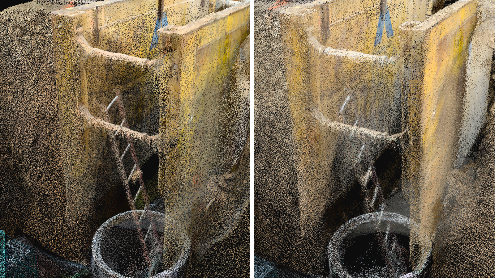
A new dense point cloud obtained with Gaussian splatting
A key aspect of Gaussian splatting at Pix4D is that it improves existing outputs, including the dense point cloud. Point clouds can often appear sparse, noisy, or incomplete in challenging environments like trenches and underground corridors, but with the new Gaussian splatting feature, an exceptionally dense and continuous reconstruction is generated, capturing even the smallest details with striking clarity. This means that pipes, conduits, soil layers, structural reinforcements, and excavation walls are now represented with significantly improved detail and clarity.
For utility applications, this enhanced point cloud brings significant advantages:
- Trench documentation: it provides clearer differentiation between materials, allowing engineers to analyze pipe coatings, detect soil shifts, and identify utility crossings
- Verifying underground installations: the higher density ensures that critical alignments and connections are faithfully represented, making it easier to check for compliance with design specifications.
- GIS and CAD integration: the richer point cloud output enhances GIS and CAD integration, offering more accurate as-built data for infrastructure planning and future excavations.
Beyond its visual clarity, the dense point cloud generated by Gaussian splatting is also geospatially accurate, making it a powerful asset for long-term underground utility management. Utility companies can now store, share, and revisit precise trench conditions at any time, reducing the need for costly exploratory digs and enabling better decision-making for future maintenance and repairs.
This new era of dense, photorealistic point clouds is not just an improvement in 3D modeling—it is a fundamental shift in how underground utilities are mapped, verified, and managed.