Digital swim: Reconstructing a waterpark from images
Holidaymakers pushing through gates to get to the pool probably don’t give the turnstiles a second thought.
But before the owners of a South Florida waterpark could add this simple upgrade, a whole new survey of the park was needed.
Cesar Rullier, director of BIM/VDC services of engineering firm Wood Environmental and Infrastructure Solutions, explains: “Turnstiles would decrease the park’s egress capacities - that is, the ability of people to safely exit the park in case of an emergency. Before the turnstiles could be installed, we had to produce a series of calculations driven by the areas of the park and its pools to understand the maximum occupancy. This allowed us to understand how the addition of turnstiles would affect occupancy and show the municipal and county authorities that people can still exit the park safely.”
The team first needed to have an accurate tally of areas and occupancies for the park. For existing facilities this information is usually found in record drawings. However, “The only drawings of the park available were incomplete and we could not locate the information we needed,” says Rullier.
| Cell | Cell |
| Cell | Cell |
| Cell | Cell |
| Cell | Cell |
| Cell | Cell |
| Cell | Cell |
“Creating CAD drawings from a conventional survey would take around three weeks as we needed to get areas and measurements of the pools, gathering spaces and pool deck, and the more accurate we could be the better,” explains Rullier. “Using drones and Pix4Dbim and some strategically located surveyed ground control points was the obvious choice for us and the client. Rather than going out with a conventional survey and spending a week and a half just surveying we captured what we needed and more in just one day.”
Project details
| Location | Naples, Florida, United States |
| Company | Wood PLC |
| Hardware | DJI Matrice 200 |
| Software | Pix4Dcapture Pix4Dbim |
| Images captured | 400 |
| GSD | 1.4cm (0.54 inches) |
Capturing the data
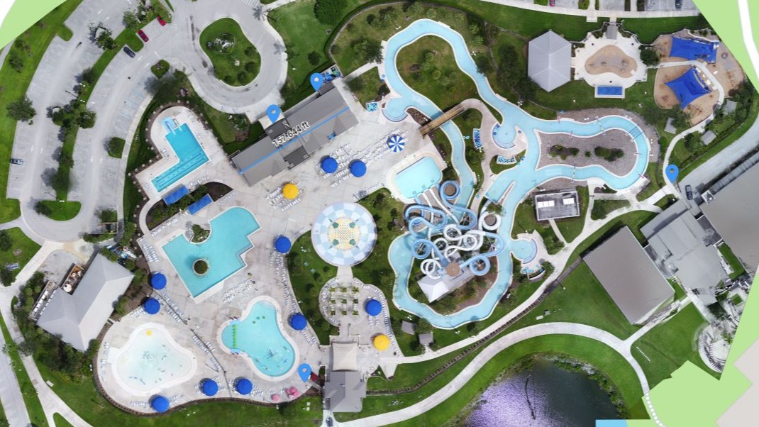
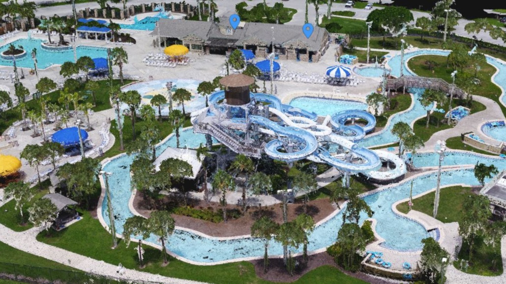
To capture the waterpark Rullier and the team selected missions from the free Pix4Dcapture app. They chose to cover the whole park with two double-grids, and a circular mission around the waterslides to capture details of the structures.
Using the Pix4Dcapture app the drone flew autonomously and performed well even in the windy conditions.
Before flying, the team established ground control points with built-in RTK, and measured the center of each with a total stick to get their precise location.
“There are some very territorial birds in the area!” adds Rullier. “We had to watch out for them, but otherwise everything went smoothly.”
Creating a 3D model in Pix4Dbim
Back in the office, Rullier processed the images in Pix4Dbim. Pix4Dbim has all the power of Pix4Dmapper, plus extra features designed for business information modeling, such as CAD overlay, and a timeline. When work on the waterpark is completed, if the team chooses to reproduce the model, they will be able to compare the changes with a click of a button.
Rather than creating separate projects to be merged later, the images were uploaded to a single project. “The images cooked for a couple of hours all together,” says Rullier. “And the model turned out great.”
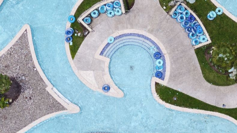
Reconstructing water
A holidaymaker wouldn’t consider an overcast day and drizzle to be good weather, but Rullier and the team did.
Water can be difficult to reconstruct, as its reflective and often fast-moving. The cloudy skies cut down on reflections in the water, and the relatively large amount of land in each frame made it easier for the software to complete the reconstruction successfully.
“The nice even lighting helped, but we didn’t do anything special to capture the water,” says Rullier. “We just laid ground control points and ran the images through Pix4D software.”
“Amazing” results
The model was exported into Audodesk Revit and the CAD files used to create the final egress diagram. “Building the virtual model was a small part of the project, but it was worth it,” says Rullier.
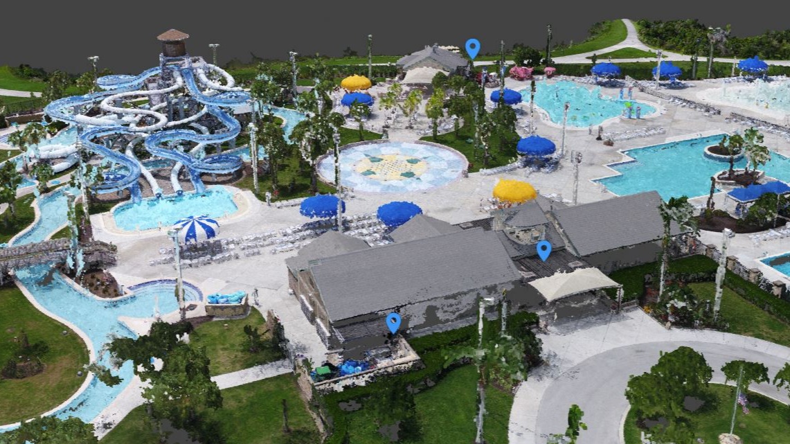
The team were able to place markers and share the results in Pix4Dbim Cloud, ensuring that the team creating the egress study were all on the same page.
Rullier estimates that a conventional survey would take around three weeks, and produce a single CAD drawing, whereas the model created with Pix4D has so much more information, and can be produced in half the time.
“I’ve presented a standard survey of a property, and asked the audience what we’re looking at,” says Rullier. “They do a relatively good job describing it, but when I turn on the point cloud from Pix4D they say, ‘Wow, that’s not what I thought it was - nowhere close.’ The amount of data you get from the point cloud is amazing.”