Closing the loop: Gaussian splatting comes to PIX4Dmatic
ADD SCHEMA MARK UP
Gaussian splatting is rapidly becoming the go-to for high-fidelity 3D reconstruction, and its arrival in PIX4Dmatic marks a major turning point. PIX4D has finally bridged the gap between mobile capture, cloud processing, and professional desktop control, offering a georeferenced workflow that stays connected from start to finish. This gives you the high-fidelity visualization of splatting without sacrificing the precision and reliability required for actual survey work.
With PIX4Dmatic, users gain full control over Gaussian splatting workflows while maintaining the accuracy, reliability, and outputs required for professional use.
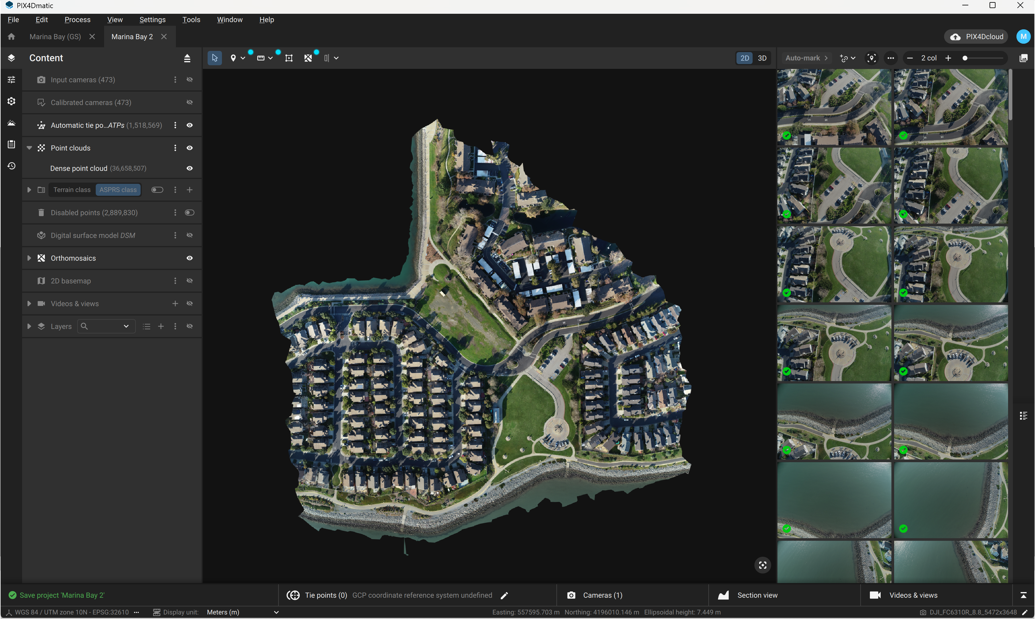
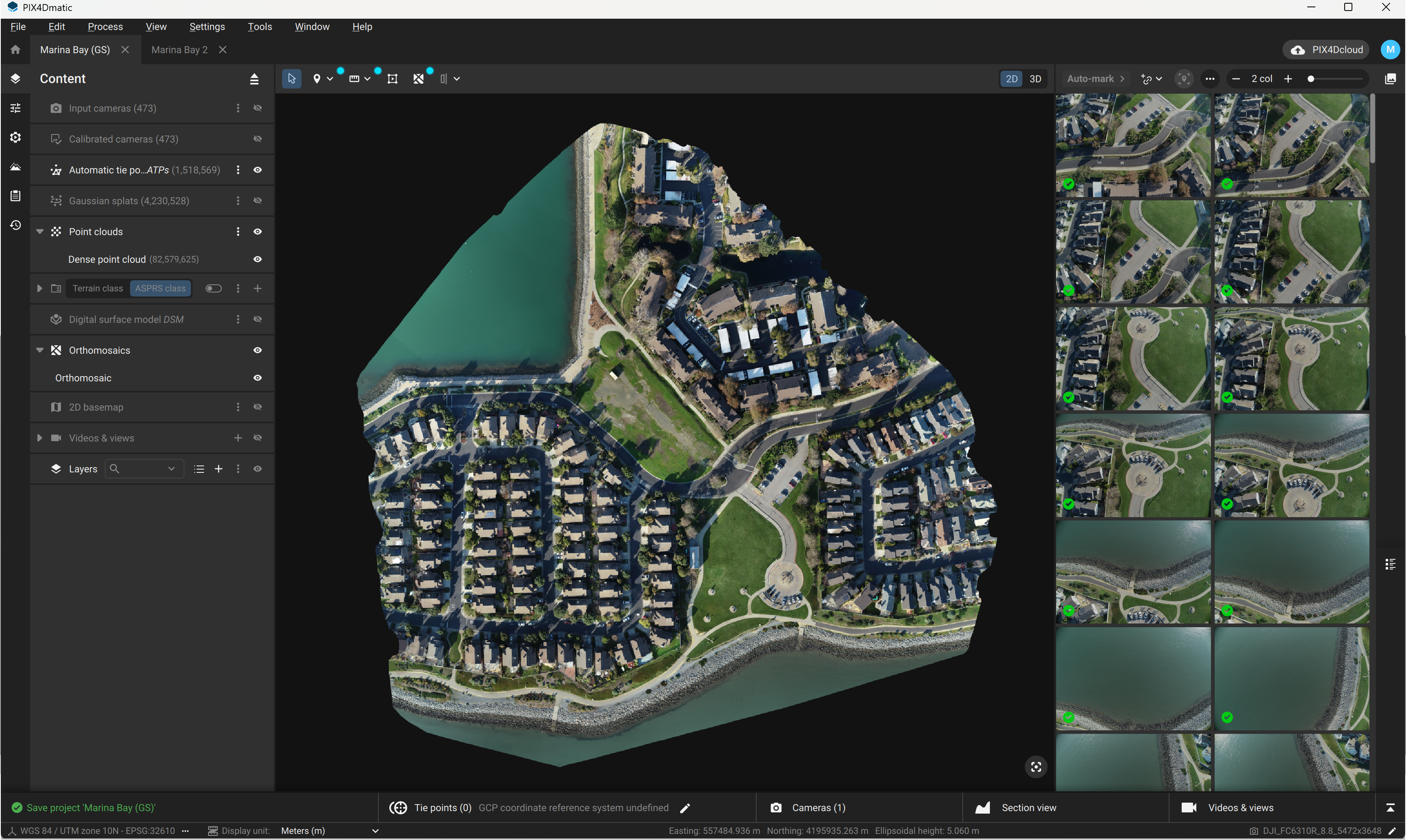
An improved point cloud
One of the most immediate and often underestimated impacts of Gaussian splatting at PIX4D is on the dense point cloud itself. In traditional photogrammetry, the point cloud is the outcome of a densification process that depends heavily on image matching quality. While effective, it tends to struggle in areas with low-texture, repetitive patterns, or complex geometry, often resulting in uneven density, gaps, or fragmented edges that require additional cleanup before the data can be used.
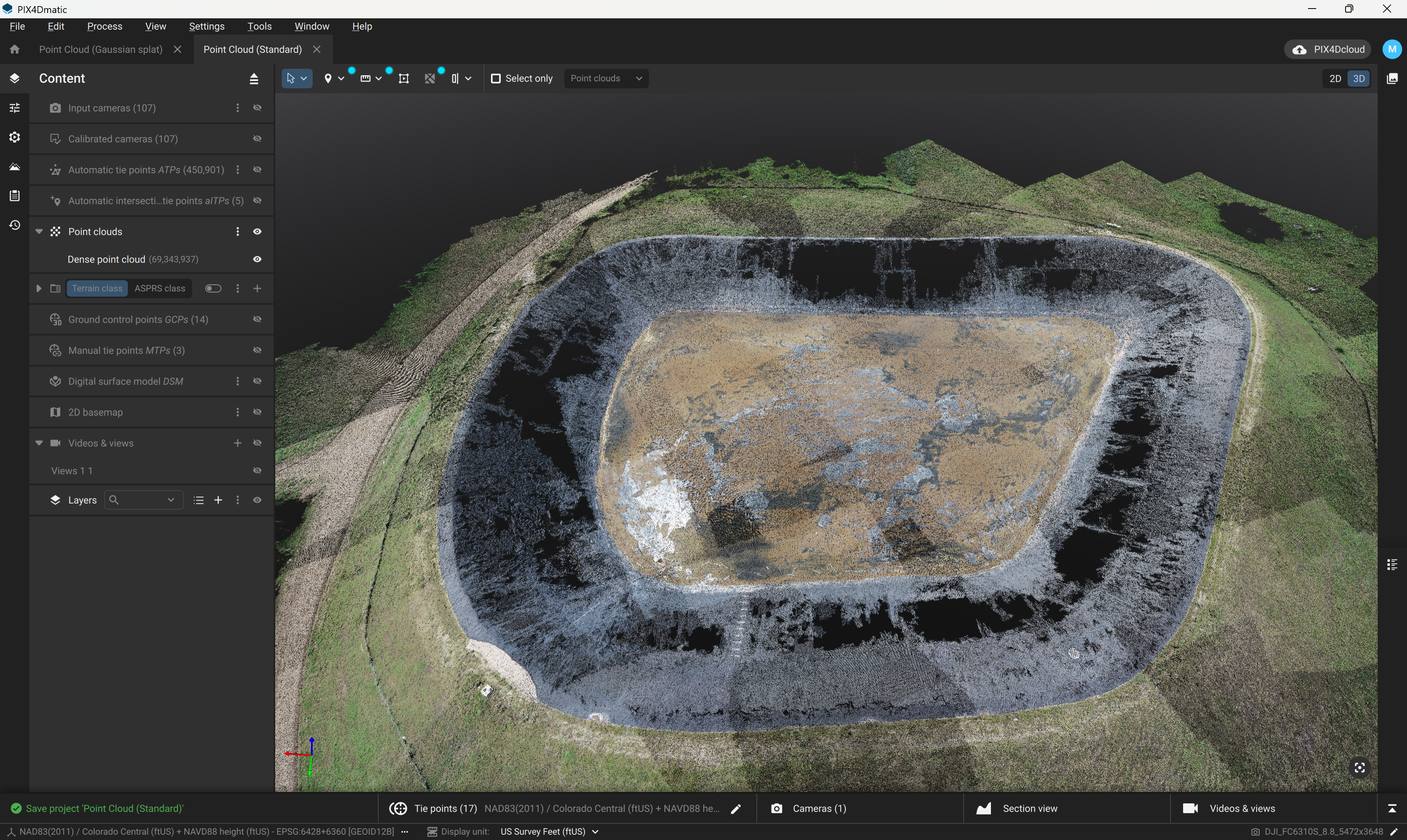
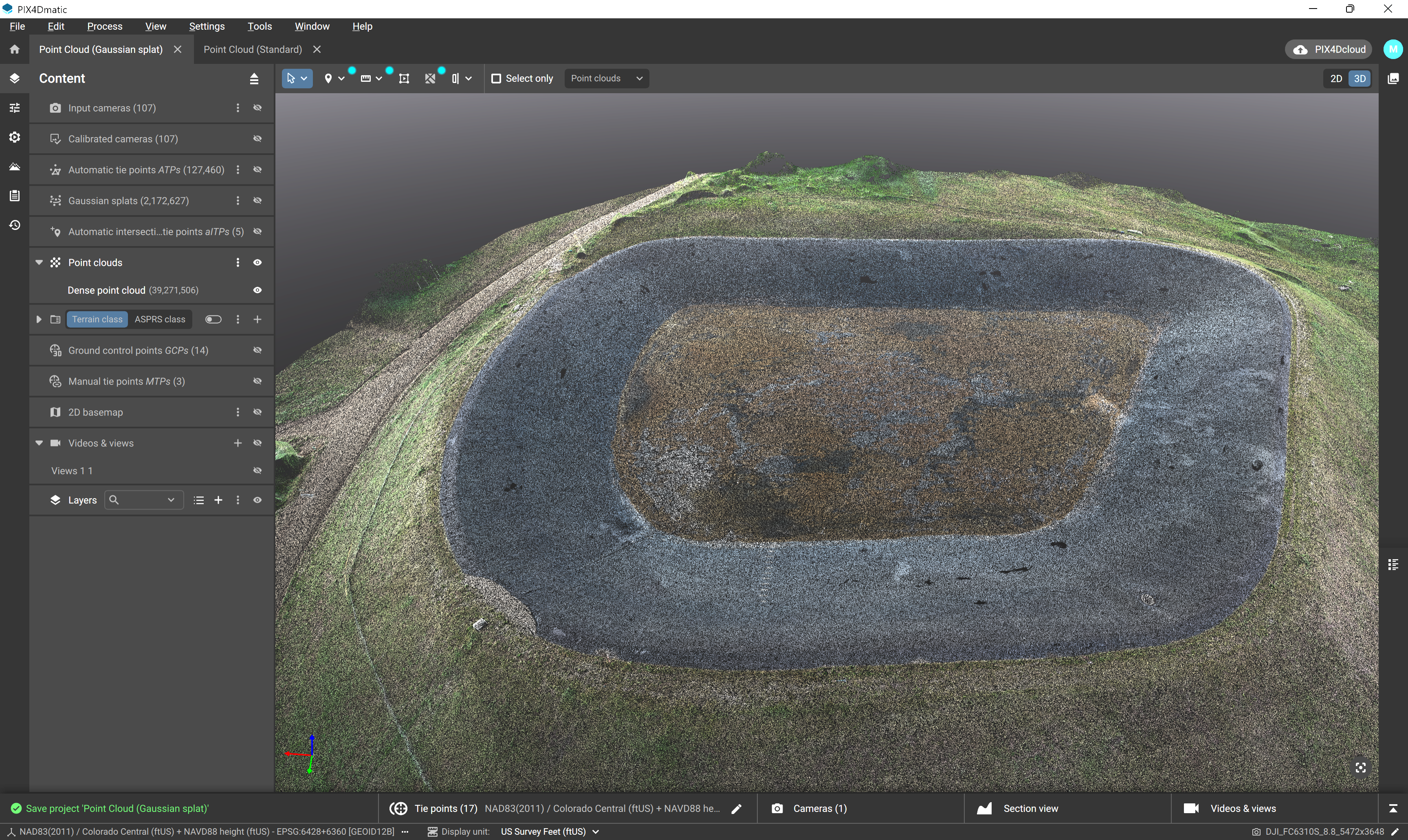
With Gaussian splatting integrated into PIX4Dmatic, the reconstruction is built on a more continuous representation of the scene, so the resulting point cloud benefits from a stronger structural foundation. This makes it more complete and more evenly distributed, while being significantly less affected by the inconsistencies (such as noise) that typically appear in challenging areas. For surveyors, this is not simply a visual improvement—it directly translates into a dataset that requires less correction and carries more reliability into the next stages of the workflow.
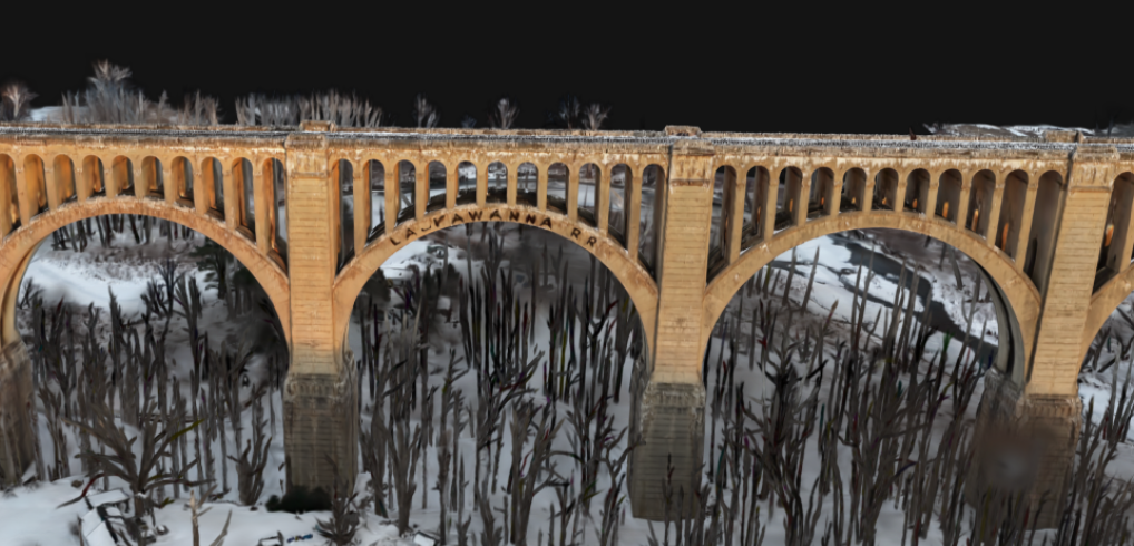
A more complete orthomosaic, even where data usually breaks down
The orthomosaic is often treated as a final deliverable, but in reality, it is one of the most sensitive outputs in the entire workflow. It exposes every weakness in the reconstruction pipeline especially in areas where photogrammetry traditionally struggles, such as water surfaces, reflective materials, or low-texture ground.
However, with Gaussian splatting in PIX4Dmatic, the scene is reconstructed as a continuous representation, and the orthomosaic retains more visual and spatial information. The result is sharper and more complete.
The orthomosaic at the top shows a more continuous and complete reconstruction, particularly along challenging surfaces like water edges, where traditional methods often struggle with gaps and inconsistencies. On the bottom, these limitations are visible through fragmented areas and less stable transitions. By improving the underlying scene representation, Gaussian splatting enables a more coherent and reliable orthomosaic, reducing missing data and enhancing overall interpretability.
For professionals, this is not just a visual enhancement. A more complete orthomosaic means fewer blind spots, more reliable interpretation, and less time spent validating or compensating for missing data. It reinforces the idea that improvements at the reconstruction level don’t stay isolated; they propagate all the way through to the outputs that teams rely on every day.
Surfaces that behave predictably
The 3D mesh is only as reliable as the data it is built from, and in many workflows, a considerable amount of time is spent stabilizing this surface—resolving irregular triangulation, smoothing transitions, or correcting artifacts introduced during reconstruction.
With a more coherent input, that effort is significantly reduced. The 3D mesh generated in PIX4Dmatic now behaves more predictably because it is derived from a dataset that is already more stable at its core. Triangulation becomes more consistent, transitions are smoother, and edge conditions are better defined, reducing the propagation of subtle inconsistencies that might not always be visible but can impact measurements.
As a result, surveyors are able to trust the outputs earlier in the process, reducing the need for iterative corrections and allowing them to move more efficiently into analysis.
Reliable volume comparisons
The new surface comparison tool in PIX4Dmatic allows you to compute volumes by directly comparing two surfaces, whether point clouds or TINs, making it possible to quantify change between surveys, design, and as-built conditions, or different stages of a project. This new tool can also be used with an imported point cloud.
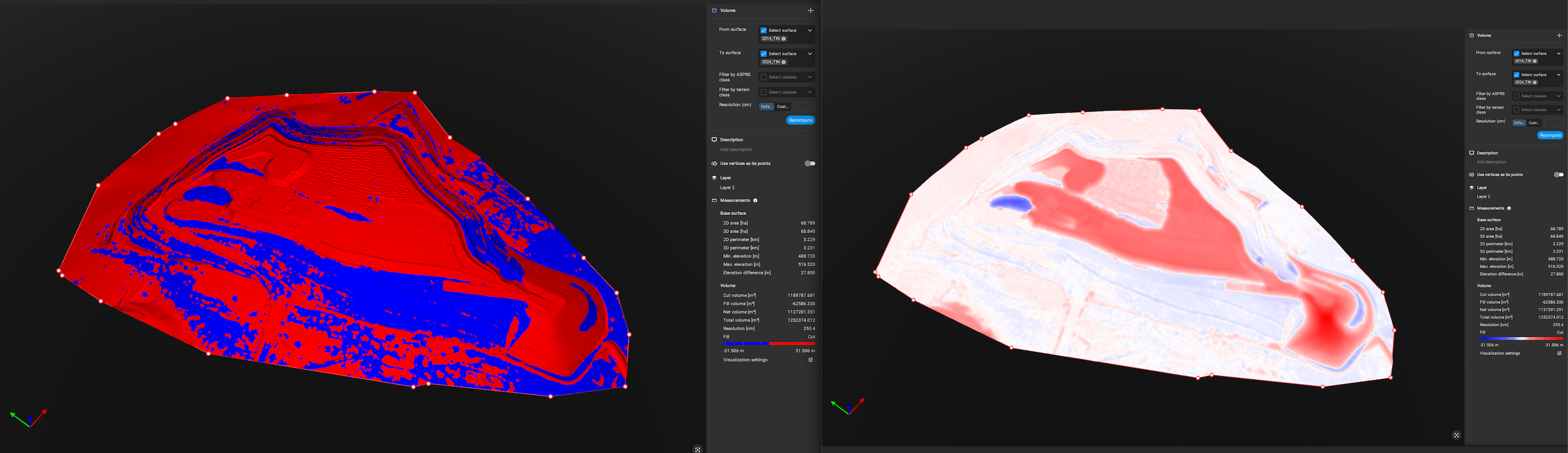
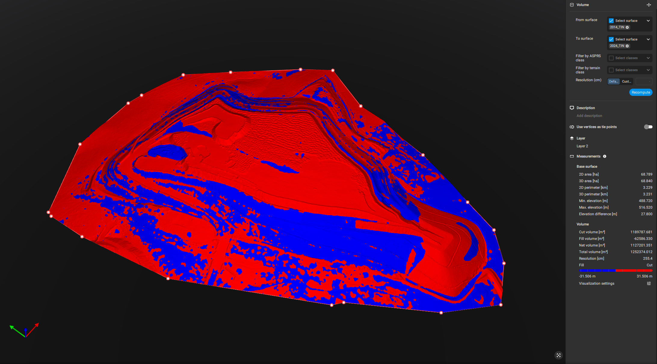
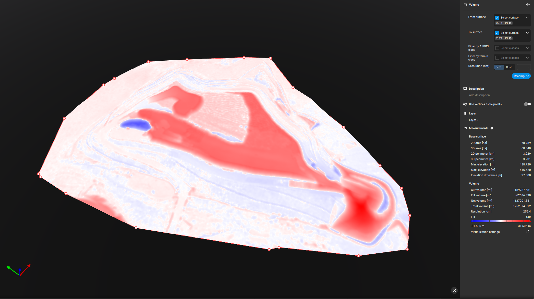
This type of analysis is inherently sensitive to the quality and consistency of the underlying data. Even small variations in reconstruction can introduce noise that appears as false change, particularly in workflows such as earthworks monitoring, stockpile tracking, or infrastructure progress analysis, where decisions depend on precise volumetric differences.
This is where Gaussian splatting plays a critical role. Producing a more complete and stable point cloud, it reduces inconsistencies between datasets at the source. Surfaces derived from these datasets align more coherently, making volume comparisons more reliable and easier to interpret.
Instead of spending time validating whether a detected difference is real or an artifact of reconstruction, surveyors can focus directly on what matters: measuring actual change with confidence.
Performance aligned with fidelity
The level of reconstruction quality introduced by Gaussian splatting is not incidental; it is directly tied to how the processing is executed.
PIX4Dmatic brings this capability into a desktop environment where performance can be fully leveraged through local GPU resources. In practice, this means that generating Gaussian splats, along with the higher-quality point clouds and surfaces that follow, benefits from modern NVIDIA GPUs with sufficient VRAM.
Achieving this level of detail and accuracy requires a powerful computer to handle the processing. These specs ensure you can generate the highest quality models directly on your desktop with speed and reliability.
However, the approach remains flexible. When local resources are constrained or when projects need to scale, processing can be offloaded to PIX4Dcloud without disrupting the workflow. The underlying reconstruction logic remains consistent, ensuring that results are aligned regardless of where processing takes place.
A connected ecosystem, not separate tools
What ultimately differentiates this approach is not just the introduction of Gaussian splatting in PIX4Dmatic, but how it integrates across the broader PIX4D ecosystem. Capture, processing, and refinement are no longer isolated steps tied to specific tools. Instead, they operate as connected stages within a single, georeferenced pipeline.
Data captured with PIX4Dcatch can be brought directly into PIX4Dmatic for advanced processing, allowing terrestrial datasets to be refined alongside aerial imagery within the same environment. This enables a more complete reconstruction of the site, where ground-level detail and aerial coverage are no longer treated separately but combined into a unified model. These results, including Gaussian splats, can easily be shared to PIX4Dcloud using the “Share to Cloud” option from the file menu.
    Reconstruction quality is aligned across platforms

    Point cloud behavior is more predictable

    Surface generation is more stable

    Data fusion becomes more controlled
At this stage, Gaussian splatting in PIX4Dmatic is no longer just an innovation in reconstruction, it becomes a structural improvement to the workflow itself. Available as part of PIX4Dmatic Pro, it is designed for workflows that require the highest level of reconstruction quality and reliability. It strengthens the starting point of every project, improves the quality of the data that flows through each stage, and integrates seamlessly into a broader ecosystem that supports how survey work is actually executed. The result is not just better models, but more reliable outcomes.