Mapping underground infrastructure with smartphones
Accurate mapping of underground structures, particularly tunnels, is vital for infrastructure maintenance, safety inspections, and urban planning. PIX4Dcatch offers an alternative to costly traditional methods such as total stations, which offer high precision but come with significant financial, logistical, and technical constraints. By integrating GNSS RTK signals, photogrammetry algorithms, and the Pix4D AutoTag technology, we offer an accessible solution for accurate mapping in areas with limited GNSS signal availability.
In this article we address the challenges of mapping underground environments, such as poor lighting and sensor navigation, and suggest best practices for mobile phone-based mapping. We tested how different scanning patterns performed in a real tunnel—and how well they held up in terms of accuracy and repeatability. Our results showed that the relative accuracy was better than 1%—a strong result for infrastructure monitoring tasks!
This article is based on a research paper by Christoph Strecha, Martin Rehak, and Davide Antonio Cucci.
Challenges of underground mapping
Mapping underground spaces is challenging, especially when GNSS signals are unavailable. Without satellite positioning, systems often rely on dead reckoning—estimating position based on movement over time. Tunnels and cluttered spaces often have poor lighting, making photogrammetry, especially Structure from Motion (SfM), difficult to use.
As a result, professionals typically prefer LiDAR for documentation and inspection. While photogrammetry can work in these environments, challenges like low light, uniform surfaces, and scale variation can affect reconstruction quality.
Modern smartphones are equipped with high-resolution cameras, sophisticated sensors, and powerful processing capabilities, enabling them to perform tasks that were once reserved for dedicated equipment. By combining RTK GNSS data with smartphone photogrammetry, users can create precise as-built models—even in tunnels where GNSS signals are limited.
This method simplifies workflows, reduces costs, and brings professional mapping capabilities to mobile devices. State-of-the-art photogrammetry algorithms allow extending the accuracy from areas with good GNSS signal reception to areas without.
The workflow is designed for users with limited surveying experience. With a shortage of surveyors in many regions, assigning scanning tasks to general workers helps reduce delays and costs. By integrating mapping into regular site workflows, projects can move forward without waiting for specialist availability.
Tunnel mapping: 3D scanning underground infrastructure
The aims of the experiments were twofold: first, to evaluate the accuracy of underground maps generated with PIX4Dcatch and second, to identify the practical challenges and limitations associated with smartphone mapping in tunnels. The series of experiments aimed to validate the absolute and relative accuracy of the 3D reconstruction, the effectiveness of smartphone-based tunnel mapping, and provide a framework for future applications.
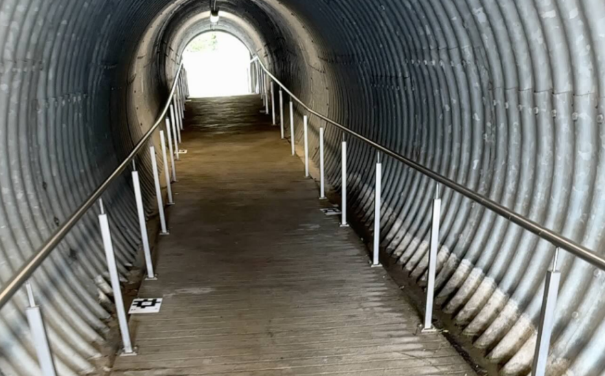
The team chose a tunnel in Preverenges, Switzerland to represent a typical structure that requires frequent and regular inspections and maintenance. This tunnel serves as a pedestrian underpass beneath a road connecting Lausanne and Morges. It is approximately 30 m long and has a diameter of 3 metres. It provides a safe passage for pedestrians and is equipped with lighting to enhance visibility and safety at night.
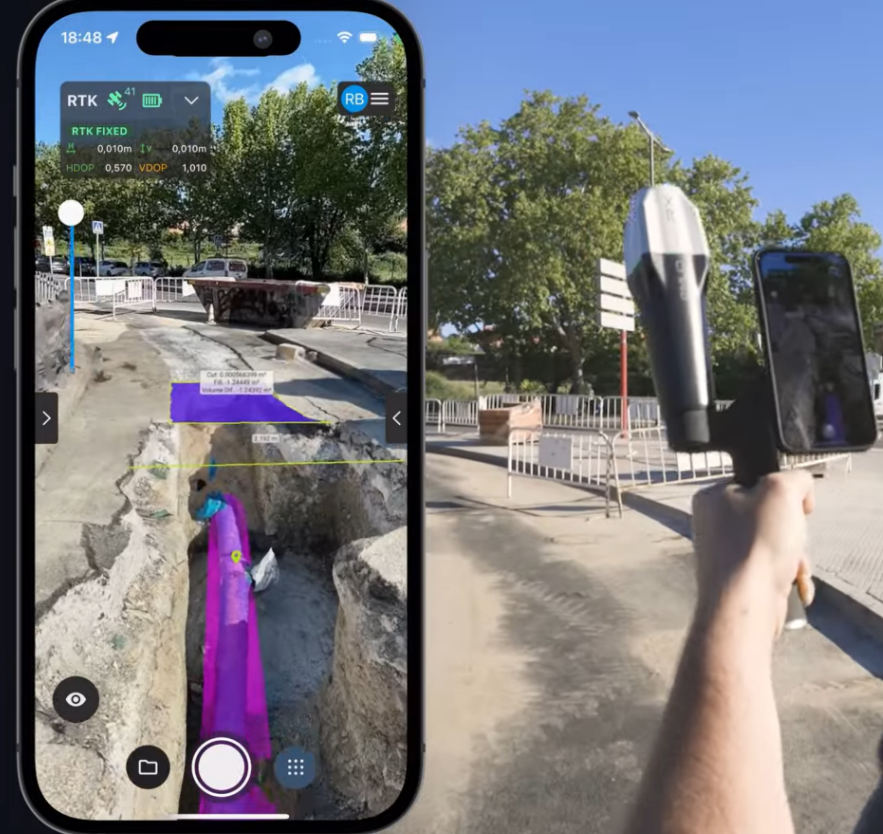
The team used an iPhone 14 Pro equipped with the Emlid Reach RX, attached to the phone via a handle and equipped with a custom-built external lighting system to enhance data capture inside the dark tunnel (the lighting addition is unnecessary in well-lit areas but improves image quality and the iPhone's tracking capabilities in low-light environments).
Smartphone data acquisition
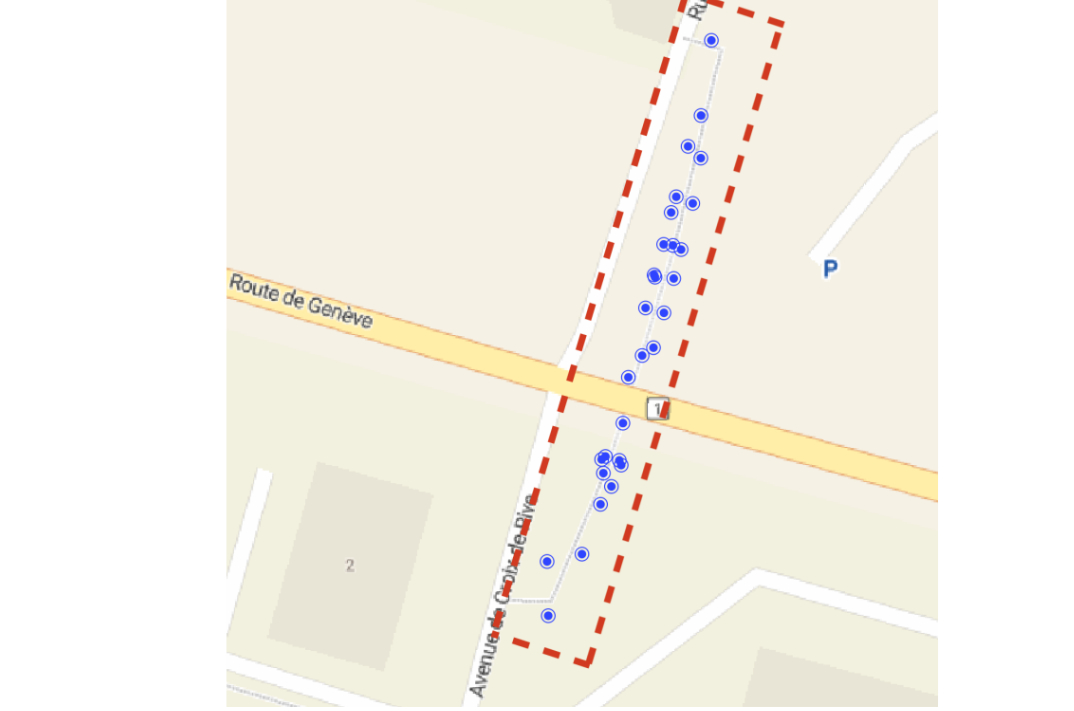
To find the most suitable scanning pattern for the tunnel, several capture techniques were evaluated, based on accuracy, ease of use, and how well they adapted to the tunnel’s shape. 10 Autotags were distributed throughout the tunnel. The Autotags play an important role in ensuring accurate mapping with PIX4Dcatch in different scenarios.
PIX4Dcatch detects points in real time and combines them with data from the phone’s sensors and the RTK receiver. Each target includes five recognizable points that are automatically extracted and used as manual tie points (MTPs) during processing. These points help improve accuracy and reduce common errors like double layers in the final 3D model.
Key features of Pix4D Autotags:
- Autotags are detected in real-time during data acquisition, enabling efficient and immediate feedback.
- The 3D position of the Autotags do not need to be known in advance, simplifying setup.
- Drift compensation is performed automatically on your smartphone, with corrections applied within seconds after data collection is complete.
- Autotags are uniquely coded and can be used to align multiple scans with each other, ensuring consistency and accuracy across different scans or sections of the scanned scene.
Only 10–15% of the images had full RTK fix accuracy, but by combining real-time detection with post-processing, the method still delivered high-quality results, even in challenging environments like tunnels where GNSS signals are limited!
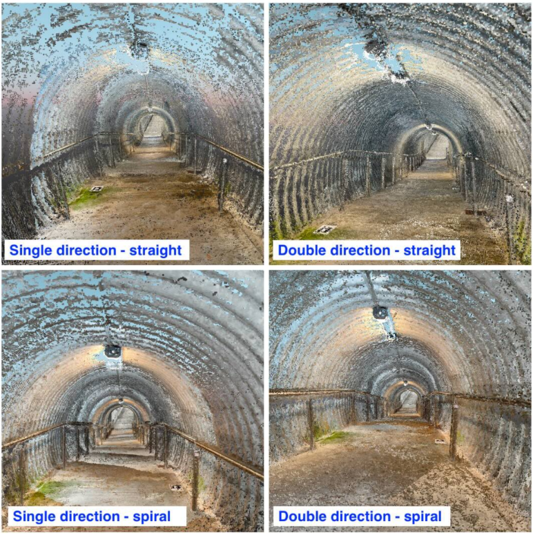
Scanning patterns
We evaluated four different scanning patterns:
- Single direction with straight pattern
- Single direction with spiral pattern
- Double direction with straight pattern
- Double direction with spiral pattern
The data was processed in PIX4Dmatic to generate a dense point cloud, 3D mesh, Digital Surface Model (DSM), and orthomosaic. PIX4Dmatic woffers advanced features like adding ground control points (GCPs), check points, and manual tie points (MTPs). The software allows users to customize the processing workflow to fit specific project needs, and all results can be visualized and further analyzed.
Pix4D’s Geofusion algorithm combined data from multiple sources—including GNSS, ARKit, and Pix4D AutoTags—to estimate the precise position and orientation of each image. The result was accurate image geotags, even in areas with poor signal or limited visual features.
The double-direction spiral pattern gave the most complete results, creating a clean point cloud with no visible artifacts. The absolute error was always under 2.3 cm, with a mean error of less than 1 mm and a standard deviation of 1.3 cm across all tests. Since the actual distances were around 2 meters, this means the relative accuracy was better than 1%—a strong result for infrastructure monitoring tasks.
Accurate underground mapping with PIX4Dcatch
This study shows that mobile phones, when combined with AutoTags, the Geofusion algorithm, and a GNSS RTK adapter, offer an accurate and affordable way to map underground environments. The method was tested in a real tunnel and delivered centimeter-level accuracy, even in areas with poor lighting, visual obstructions, and no GNSS signal.
Among the scanning patterns tested, the double-direction spiral method produced the most complete and artifact-free point clouds. While single-direction scanning works well for simple tasks like tarmac inspections, more complex tunnels benefit from two-direction scans for full coverage. AutoTags were key to maintaining accuracy, especially when merging images from different passes.
This workflow is accessible to users with little or no photogrammetry or surveying experience, and it reduces the cost and complexity compared to traditional tools like LiDAR or SLAM-based systems. Its ease of use makes it practical for a wide range of tunnel mapping tasks and supports broader adoption in construction, infrastructure, and urban planning projects.