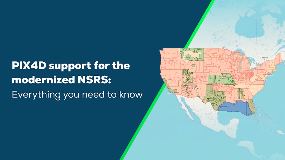
The Modernized National Spatial Reference System (NSRS)
This article was written by Javier Jimenez Shaw, Expert R&D Engineer at PIX4D
The National Geodetic Survey (NGS), part of the National Oceanic and Atmospheric Administration (NOAA), is now in the final phase of releasing the Modernized NSRS. This new set of coordinate reference systems (CRSs) will replace the current family of systems based on NAD83 and the vertical datum NAVD88.
The coming set of CRSs is completely new: the geographic systems, SPCS, vertical system, and geoid models, as well as state planes with “similar” names. Trying to mix components from the old and new systems will lead to incorrect results. Reacquisition or transformation is needed.
PIX4D will support the new systems and transformations as soon as possible after they are officially published.
Why is the NSRS being modernized?
The accuracy of a reference system depends on the quality of the base stations and monuments used to define it. Over the years, some of the monuments defining the NAD83 family have deteriorated or been destroyed. Maintaining the remaining monuments has become difficult and expensive.
The misalignment of the Earth’s center by 2.2 meters -7.2 ft- in the North American Datum of 1983 (NAD 83) has to be corrected. In addition, the North American Vertical Datum of 1988 (NAVD 88) is both biased (by about half a meter -1.5 ft-) and tilted (by about 1 meter coast to coast -3 ft-) relative to the best global geoid models available today.
Correcting the misalignment of the Earth’s center is important to obtain proper elevations (geopotential values) and to accurately use GNSS data. Satellite orbits are in reference to the Earth’s center.
The NGS has been working for more than 15 years on a completely new set of CRSs that address these problems, ensuring accurate measurements with the latest technologies, including more accurate GNSS devices and services.
How big is the change?
Due to the change in the center and position of the datum (and new geopotential model), there is an immediate initial shift:
- Horizontal change: 0.5 to 4 m (1.5 to 13 ft)
- Ellipsoid height change: ±2 m (±6 ft)
- Elevation change: -0.5 to +2 m (-1.5 to +6 ft)
Afterward, there will be continuous drift due to tectonic movements and deformations. Take into account that the new model is using the epoch as a variable.
Current status of the modernized NSRS
The modernized NSRS is currently in beta, but the latest revision is expected to be released as is. Once it is submitted to the FGCS and approved, it will become official. This is expected to happen in the near future.
The modernized NSRS naming
This modernization brings many names and acronyms. Here are some of them:
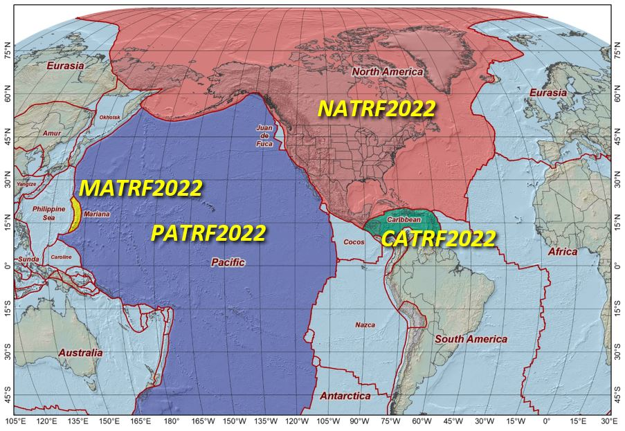
NATRF2022: North American Terrestrial Reference Frame 2022 PATRF2022: Pacific Terrestrial Reference Frame 2022 CATRF2022: Caribbean Terrestrial Reference Frame 2022 MATRF2022: Mariana Terrestrial Reference Frame 2022 (in this document we sometimes use xATRF2022 to refer to any of them) SPCS2022: State Plane Coordinate Systems of 2022 NAPGD2022: North American-Pacific Geopotential Datum of 2022 EPP: Euler Pole Parameters
How does the NSRS modernization affect me?
It is a completely new horizontal and vertical datum, similar to what happened in the migration from NAD27 to NAD83. Well, back then computers were not in every pocket as they are nowadays, so this time it should be easier. But at the same time, users will expect more accuracy. And faster.
Administrations and companies will start publishing their coordinates in the new system. Requirements for new contracts will slowly move to use it. GNSS devices and services will publish their data/corrections in the new system. At some point they will stop supporting NAD83(2011).
Current and old projects will have to update their records if they want to be in sync with new data.
Land surveyors will have to know how to deal with the new coordinates and new SPCS.
But don’t worry: it is not difficult once you understand it.
How the model works
Framework architecture & coordinate transformations
The new NSRS is based on the International Terrestrial Reference Frame from 2020 (ITRF2020) at epoch 2020.0. The four different terrestrial reference frames xARTF2020 are attached to their respective tectonic plates. All of the frames are identical to ITRF2020 at epoch 2020.0 (January 1, 2020). As time elapses from 2020.0, each reference frame rotates with the stable part of their tectonic plate.
The transformation from ITRF2020 coordinates to xATRF2022 coordinates comprises two different components.
The first component is a Cartesian time-based datum transformation based on Euler Pole Parameters (EPP). This transformation allows the transformation from ITRF2020 into xATRF2022 at the same given epoch in both systems. The parameters have been chosen to minimize the change of coordinates of a real world point over time. The EPP transformation can be easily implemented with a 15-parameter Helmert transformation with all zeros except the three rotation velocities and the reference epoch to 2020.0. The EPP transformation is only transforming from ITRF2020 into xATRF2022; it is not changing the epoch.
The first component treats the tectonic plates as rigid, which is not the case in reality. The second component, named IFDM2022 (Intra Frame Deformation Model), models crust deformations in geodetic coordinates and allows going back in time from xATRF2022 coordinates at epoch t_1 to epoch t_0 (usually 2020).
Deformation modeling & epoch consistency
Figure 1 represents the horizontal velocity of the ITRF2020 coordinates of a few CORS stations and the location of their associated Euler Pole solution for the North American Plate. When we subtract from the velocities the vectors modeled in the first component of the transformation, we are left with the residuals shown in figures 2 and 3, which are in fact the velocities of the stations in NATRF2020. These residuals are modeled by the second component mentioned above (IFDM2022). As can be seen, the residuals are in general one order of magnitude smaller than the original velocities.
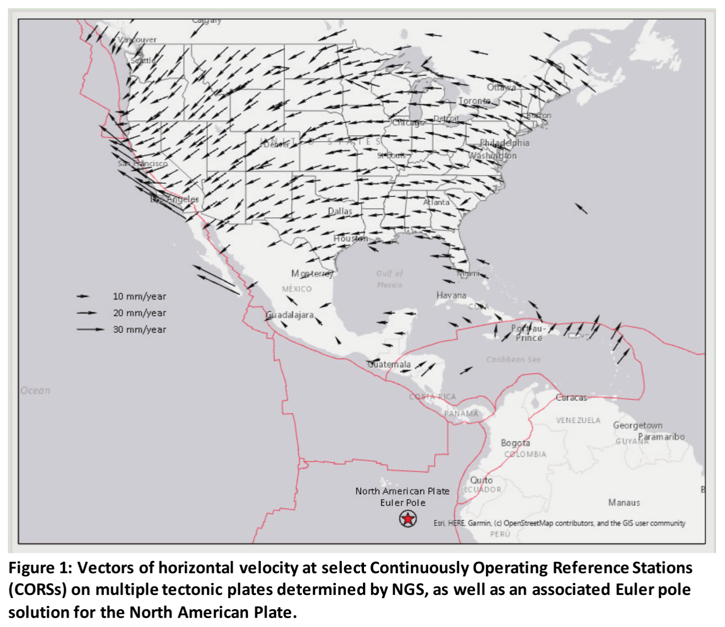
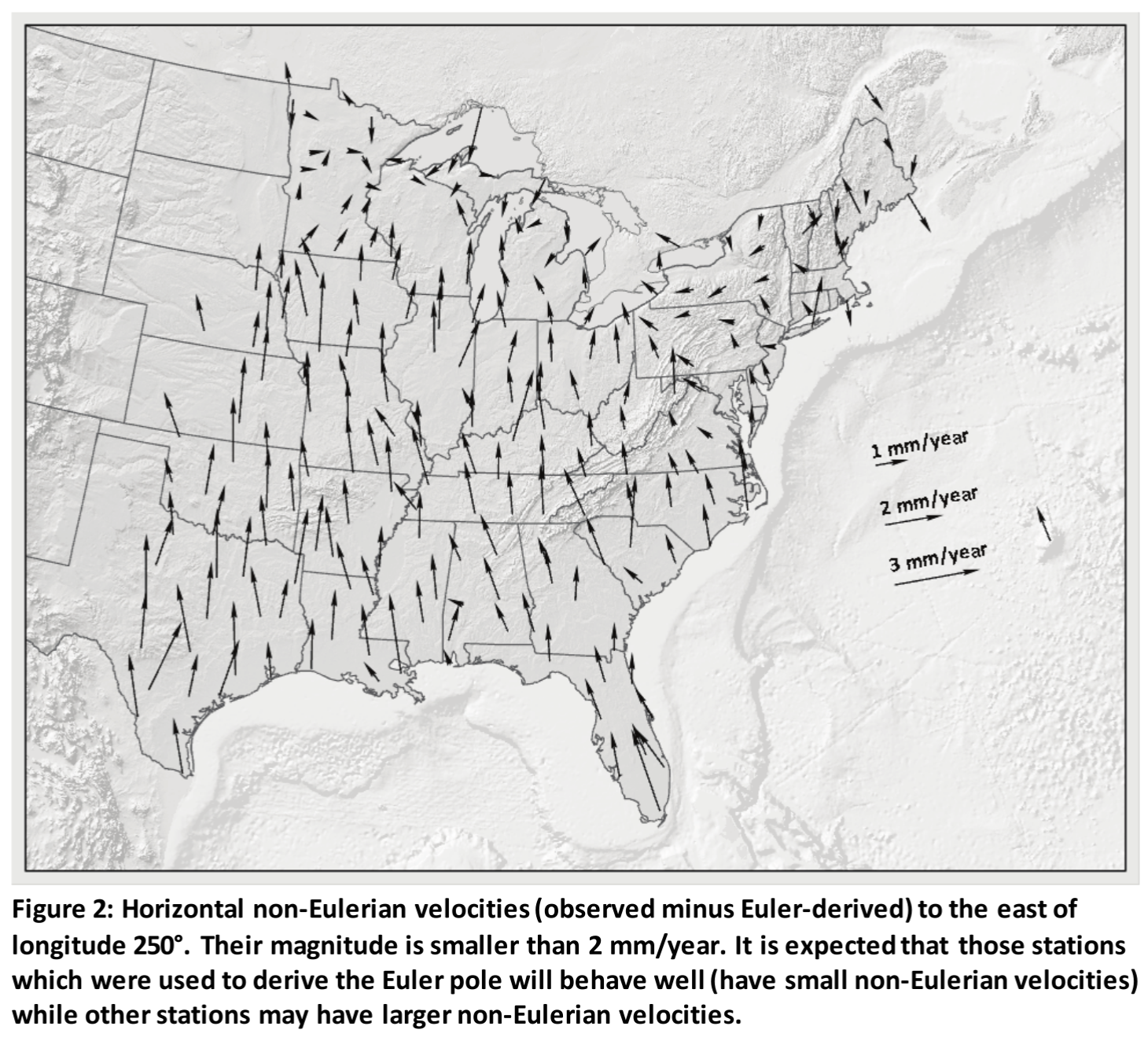
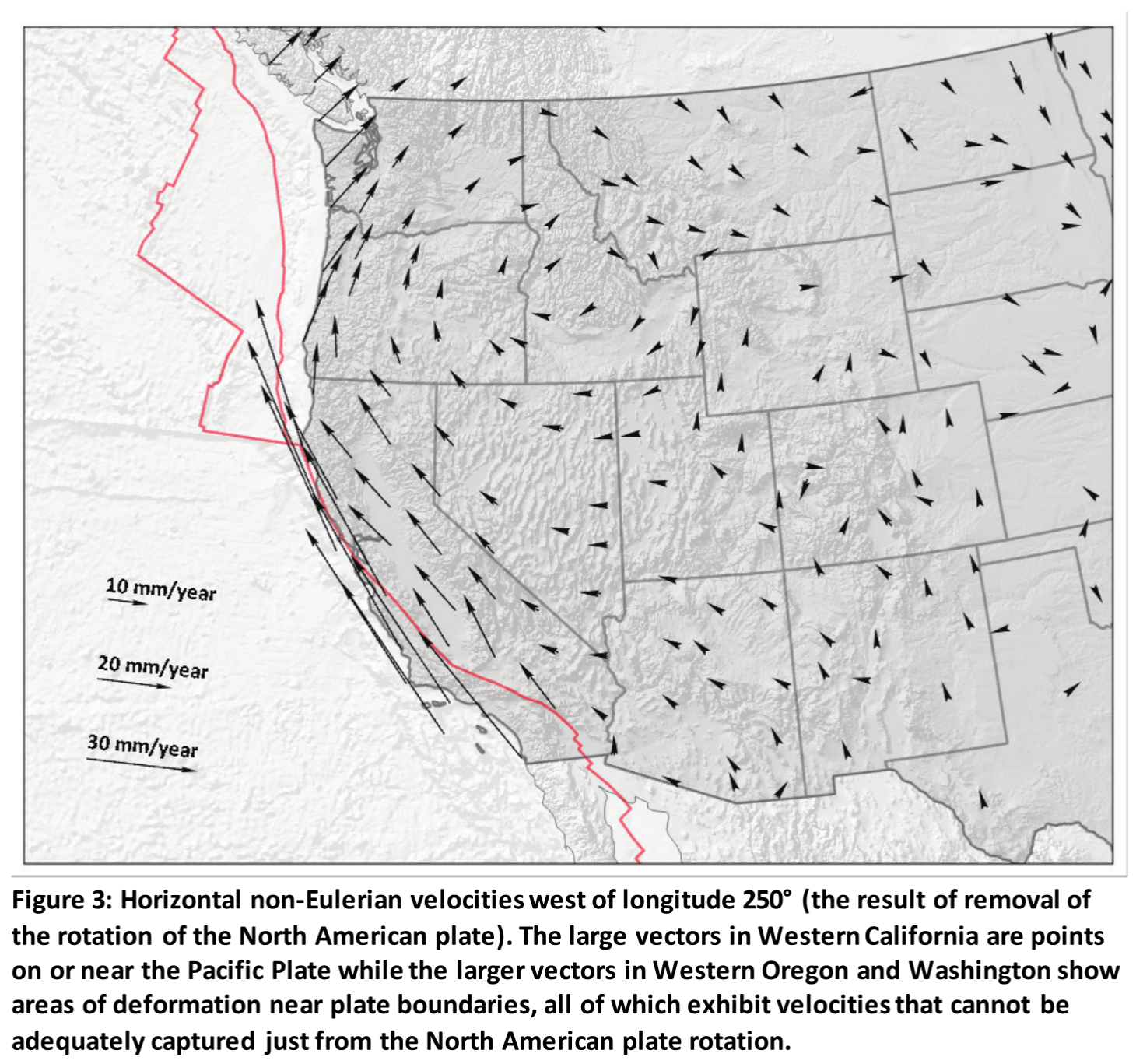
Source of the images: “NOAA Technical Report NOS NGS 62. Blueprint for the Modernized NSRS, Part 1: Geometric Coordinates and Terrestrial Reference Frames”
To compare “apples to apples,” the coordinates have to be in the same epoch. Usually this is done at epoch 2020.0.
We expect that most of the processed coordinates will be provided in epoch 2020.0. That will allow the operators to use them properly. Do not remove this information to simplify things. It is still important to avoid misunderstandings.
Understanding SPCS2022
The old SPCS83 has been used for a long time. Now that the underlying geographic system has been replaced (including a significant offset, as explained before), the state planes have to be redesigned.
This opportunity was used to create a new set of projected reference systems which are smaller and more adjusted to the orography to minimize the distortion at the topographic surface. Something known in the field as LDP (low distortion projections). This is not a new mathematical projection method, but just an adjustment of the parameters of a known projection method to minimize the distortion on the topographic surface, not on the ellipsoid. In addition, populated areas had a bigger weight while computing the parameters of these LDPs.
To avoid some misunderstandings, the false easting and northing of the existing SPCS have been significantly changed (in addition to other projection parameters). That will produce clearly different coordinates in “NAD83 / California 1” vs “NATRF2022 / California 1”
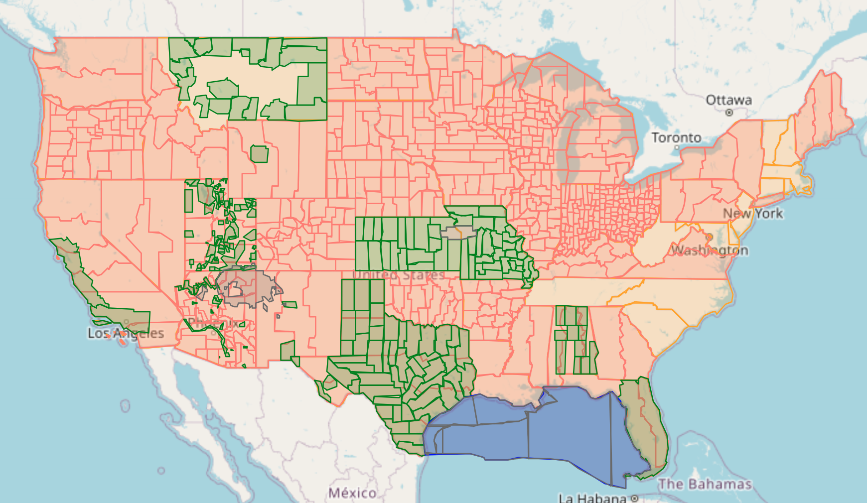
These new SPCS are classified in 4 different groups:
- Statewide
- Multizone complete: complete partition of states
- Multizone partial: partial partition of states
- Special Use: Systems over more than one state (Navajo Nation and Kansas City) and the Gulf systems
Notice that one state may have both partial and complete systems. So for the same point, there can be up to four SPCS
You can find the new set of SPCS2022 in this interactive page. The data is based on the beta information published by the NGS.
You can find more information about the process to generate them in this interesting presentation by Michael Dennis.
By the way, only the meter and international foot (1 ft = 0.3048 m) are used. The “US survey foot” (deprecated in 2022) is not used anymore in SPCS2022. Of course, it will stay for the old systems in NAD83.
If you pay attention, the projection parameters (false easting and northing) are almost always whole numbers in both meters and feet. They were selected that way on purpose to avoid rounding errors.
The new vertical system and its geoid model
The North American-Pacific Geopotential Datum of 2022 (NAPGD2022) will serve as the geopotential datum within the National Spatial Reference System. It covers three regions: the North American–Pacific region, Guam and the Commonwealth of the Northern Mariana Islands, and American Samoa.
Its geoid model GEOID2022 is already published as beta and provides the connection between ellipsoidal heights determined with GNSS and orthometric heights.
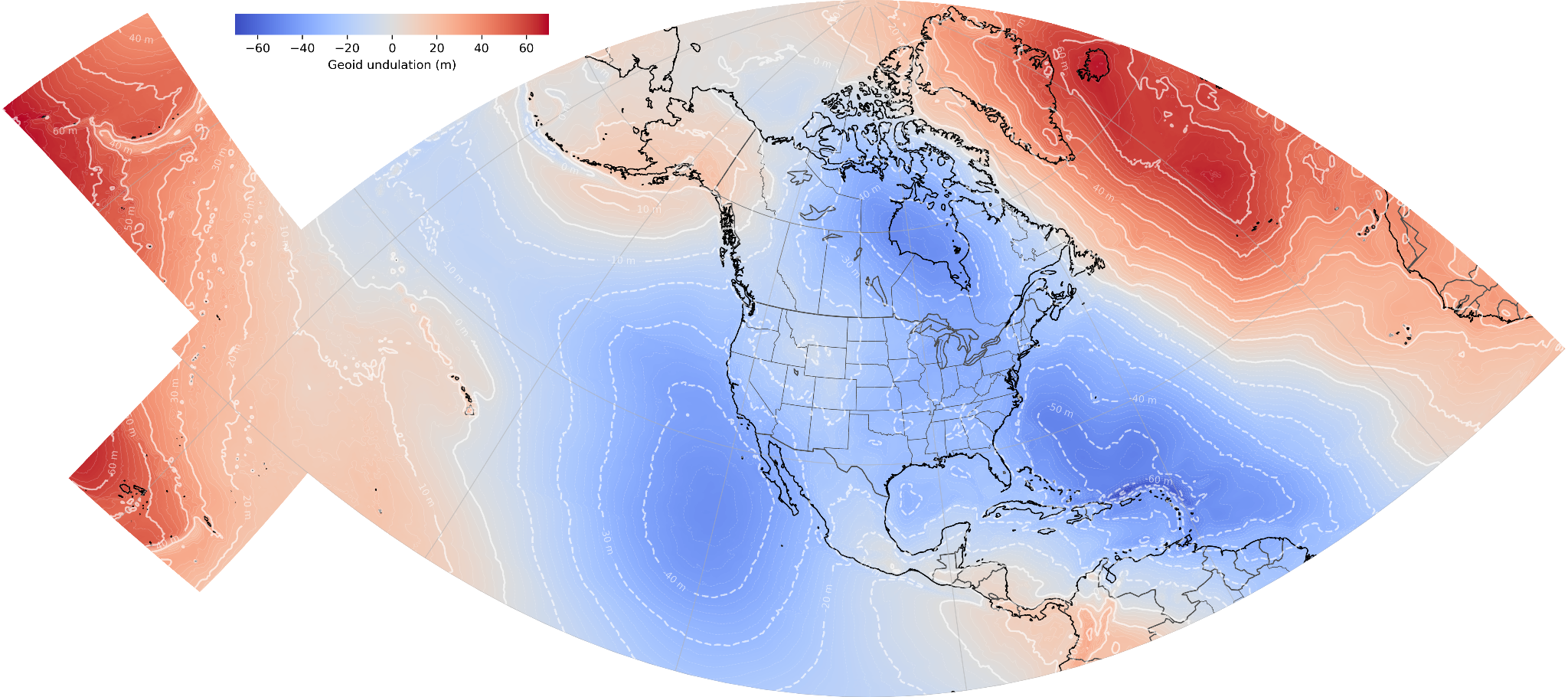
In NAPGD2022, the orthometric height (H) is defined as the ellipsoidal height (h) minus the geoid undulation (N). It is not an approximation but a definition:
H ≡ h - N
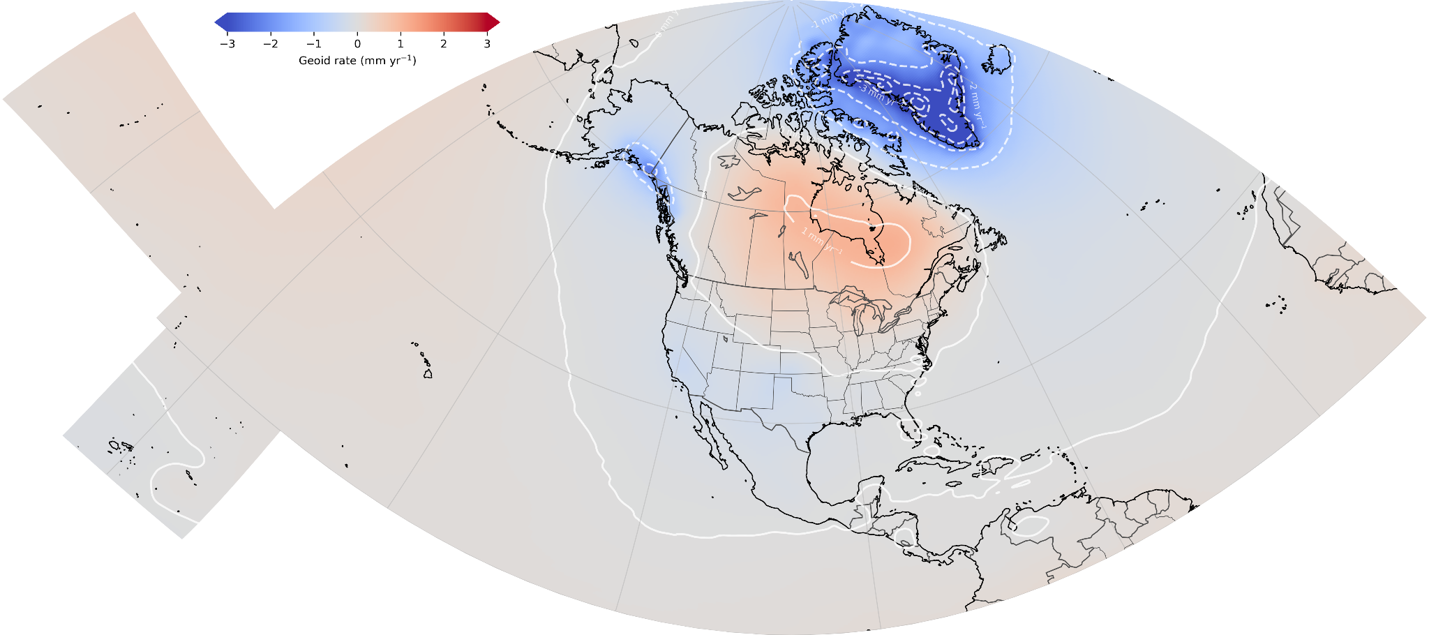
This geoid model also has a velocity component (with epoch 2020.0). It is more significant in the northern part of Canada due to the flow of extra material into the mantle below Hudson Bay, and Alaska due to the secular deglaciation.
This geoid model and the previous ones (GEOID18, etc) are using different references (ITRF2020 vs NAD83*), so their values are not directly comparable.
How is this modernization affecting my NTRIP (RTK) connection?
Provider updates and mountpoint selection
Local NTRIP providers will include corrections in xATRF2022 at a specific epoch sooner rather than later. Due to the significant difference with respect to NAD83(2011), NAD83(PA11), etc, we expect them to create new mountpoints, ports, or even URLs for xATRF2022. Hopefully they will provide both corrections at some time. Please read your provider’s documentation about it once they move to this new CRS.
Later, when you select your NTRIP on your device (drone, PIX4Dcatch, etc), pay attention to select the corrections in the CRS you expect, and document it. Otherwise, you will not be sure about your acquisition. Afterwards, in a processing software like PIX4Dmatic, you should select that CRS for your images to make everything consistent.
CRS documentation and the NTRIP catalog
In case you are measuring GCPs, do not forget to document the CRS. Coordinates without a Coordinate Reference System are meaningless numbers!
We recommend that you ask your provider to register in https://ntrip-catalog.org. It is an open source / open data project collecting precisely the CRS information from different NTRIP providers worldwide. We explain it in an example here. The ntrip-catalog is currently used by PIX4Dcatch and other software. If your provider data is in the ntrip-catalog, then PIX4Dcatch will automatically identify the CRS and tag the images properly. No questions, no mistakes. Use the ntrip-catalog search tool to see if your provider is included.
The Florida Permanent Reference Network (FPRN) is already using NAD83(2011), NATRF2022, WGS 84 (G2296), and ITRF2020 using different ports. You can already see its NTRIP-catalog JSON configuration file. Notice how for NATRF2022 they use epoch 2020.0.
Will my site localization/calibration automatically work?
A site localization (a.k.a. site calibration) allows you to georeference a local CRS. Depending on how it was created and defined, the usage with the modernized NSRS will be more or less accurate. You can always recreate it re-acquiring your reference points in xATRF2022. To produce it as a WKT there is a PIX4D tool available.
Is the NSRS going to be available in PIX4D products?
Yes. PIX4D products will include them when they become official. At that time we expect that all the information is in the EPSG dataset, and later in PROJ, the geospatial library we use. Every product will tell the news in their respective release notes.
Happy surveying!