How PIX4Dmatic automatically corrects measurement distortion
While most GIS and photogrammetry software requires a user to manually manage distortion by choosing appropriate projections or running specific tools, PIX4Dmatic has a built-in, automatic feature to handle this. The Distortion-Aware Measurements feature adjusts for the differences caused by projection distortion, ensuring your measurements are as accurate as possible.
The information in this article was provided by Lukas Juschka
Why are my measurements distorted?
Projection distortion
All map projections, by necessity, distort the world. Think of trying to flatten a spherical orange peel—you can't do it without stretching or tearing it. Similarly, to represent the curved Earth on a flat map, we must make a trade-off.
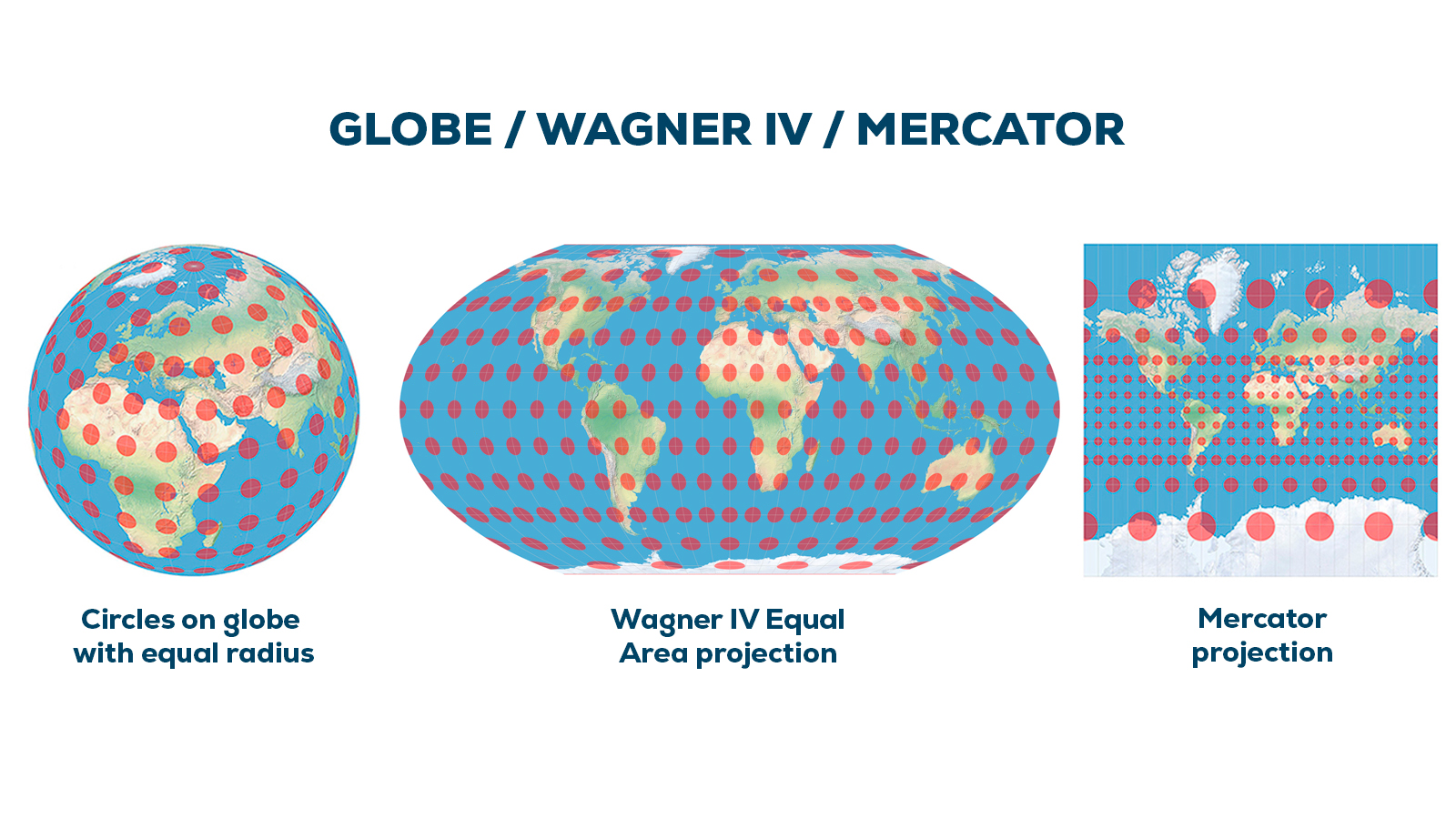
Some projections preserve the true area of landmasses (like in the Wagner IV projection, where all circles have the same size), but they stretch and distort the shapes.
Other projections, known as "conformal" projections (like Mercator), preserve the correct local shapes and angles, but they distort areas and distances, especially the further you get from their intended area of use.
This is why accurately geolocated points that are, for instance, one meter apart in the real world will not necessarily be one meter apart on a projected map. The choice of projection determines which type of distortion you get. For technical work like surveying, it's crucial to understand these distortions because they directly impact the accuracy of your measurements.
In geospatial software, you will choose your coordinate reference system (CRS) based on your needs or project requirements, but inherent projection distortion will always be present, regardless of the CRS selected.
How large is the effect of projection distortion?
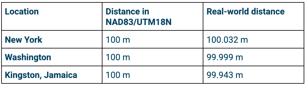
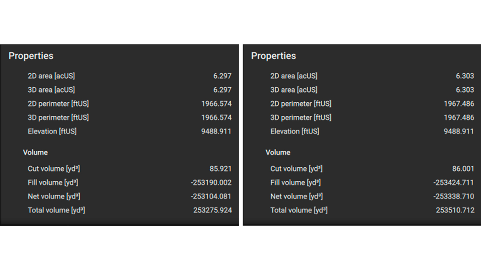
In a good coordinate reference system for surveying, the effect is small, but it is still noticeable. For example:
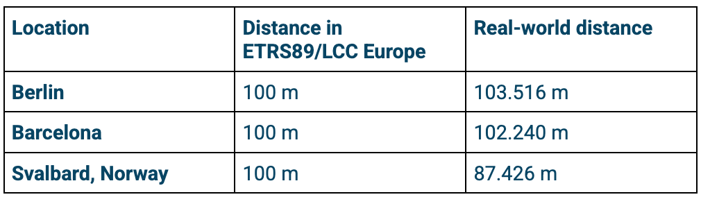
However, if the CRS is not good, the difference becomes more drastic:
What makes a coordinate reference system "good" or "bad"?
A combination of different effects makes a CRS "good" or "bad". Each coordinate reference system has a different "area of use". This restricts the area that surveyors are supposed to use the CRS in. Some coordinate systems have very large areas of use, while others are extremely specialized.
If the area of use is smaller, the parameters of the coordinate system can be more fine-tuned to work well for this location. In the USA, for example, the new State Plane Coordinate System of 2022 (SPCS2022) is creating hundreds of small coordinate systems to better fit each location. Meanwhile, the area of use of ETRS89/LCC is enormous, which is why the distortion factors for it are bad.
Different projections have different properties, each serving different needs, uses, or industries. For example, some are better for navigation (naval or aviation), and some are better for surveyors. As a surveyor, you ideally want to use a conformal projection that also has low distortion factors in your area.
Distortion due to elevation
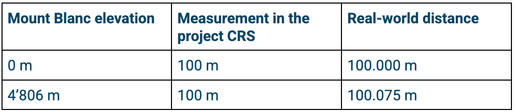
In addition to projection distortion, there is elevation distortion: a projected CRS has the same distances between two points regardless of elevation. Because the Earth is round, the real-world distance is longer at higher elevations than the flat distance shown on a map. If uncorrected, this difference due to elevation can lead to significant errors in distances and areas, particularly in mountainous terrain.
PIX4Dmatic automatically accounts for both types of distortion to ensure your measurements reflect true ground values.
How PIX4Dmatic accounts for measurement distortion
Most geospatial software requires the user to perform extra steps, such as manually choosing a highly localized coordinate system or applying a specific scale factor to get accurate measurements.
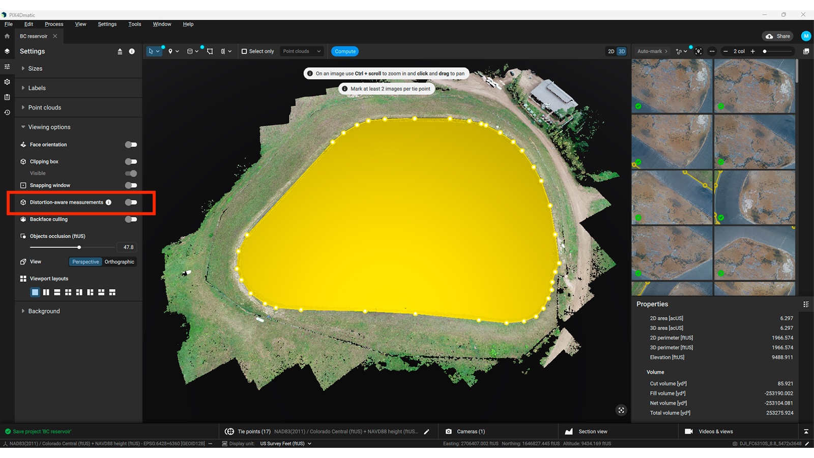
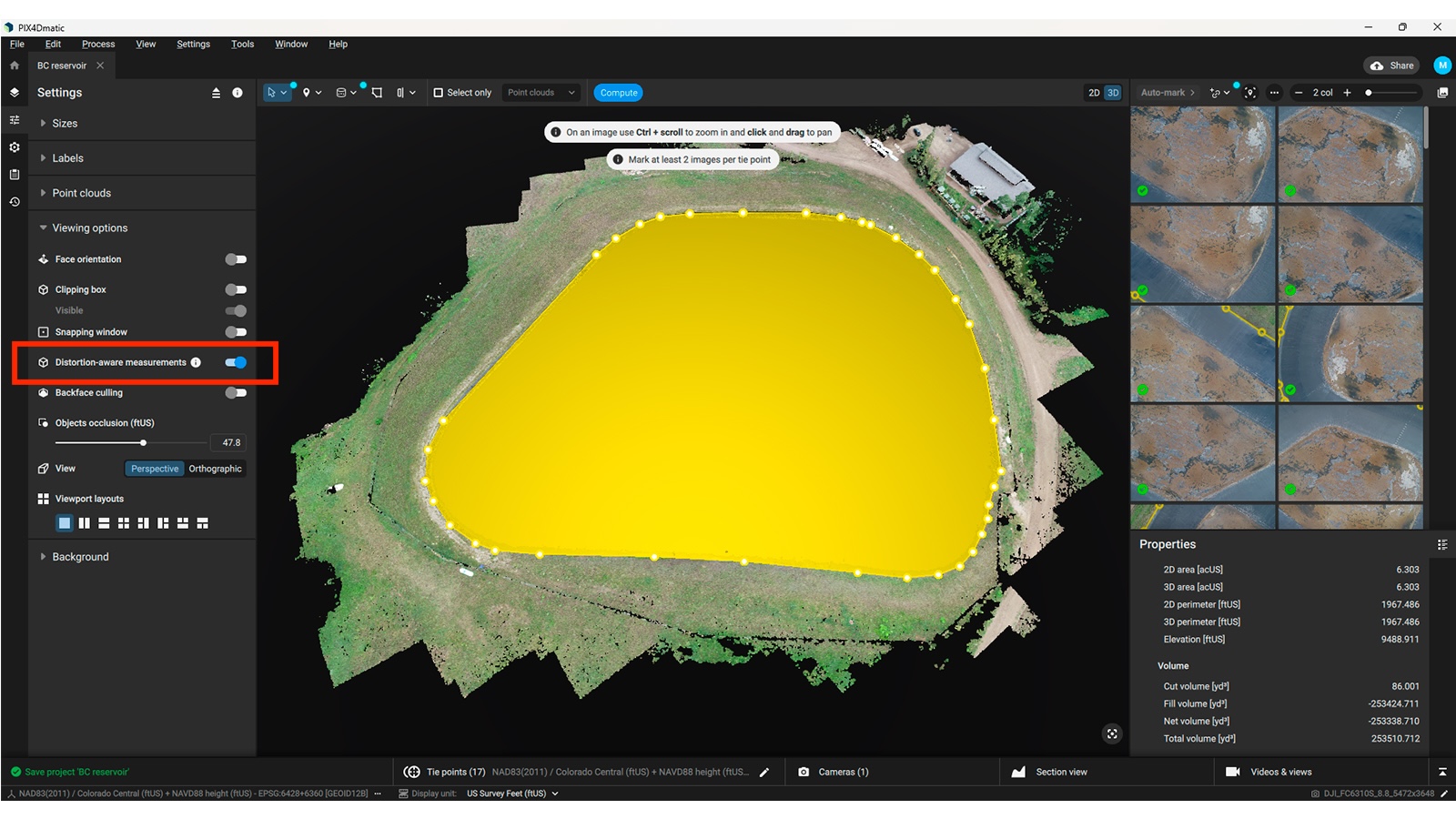
This is where PIX4Dmatic simplifies the process. With PIX4Dmatic’s distortion-aware measurements, you have real-time corrections built into the software. If the setting is on, every measurement of a distance/area/volume you see in the application is adjusted. The feature accounts for these distortions to ensure measurements match the real world as closely as possible.
Unlike many other programs, it automatically calculates and applies the necessary corrections behind the scenes, ensuring that a meter in the software is a true meter on the ground without any manual work.
Here's how it works in PIX4Dmatic:
For outputs: When enabled, every measurement of a distance, area, or volume you see in the application is automatically converted from its "projected CRS" value to its true "real-world" value. This means what you see on your screen—whether it's the distance between two points or the area of a roof—is a reliable, real-world measurement.
For inputs: The feature also works in reverse. When you define a measurement, such as setting the length of a scale constraint, the value you enter is interpreted as a real-world measurement. The software then automatically accounts for the projection distortion to ensure your input is applied correctly, making sure your model is accurately scaled and geolocated.
Bear in mind that for very large projects, or for images taken from a great height (for example, by plane or satellite), the distortion correction gets less accurate. The feature calculates the scale factor for the entire project from its center point, rather than at each point. If you would like to see the difference, you can always turn the feature off in the project settings.
This advanced capability ensures that your projects are built on the most precise data possible, helping you overcome the inherent limitations of map projections.
Got questions, or want to get involved? Join the conversation on LinkedIn and follow our hashtag #Pix4DLabs